DRAFT
Briefing to NASA Concerning Bicycle and
Pedestrian Access to and Around the Proposed Research
Park
Prepared by Denis Newman and Klay Lund,
July 30, 2000.
Newman has done extensive mapping of bayland
bicycle trails. Lund is an avid bicycle commuter and formerly with the 129 CANG/CES
based at Moffett. Please address comments or
questions to denis@newmannet.com
Goals:
- Bicycle and pedestrian access to and among the public
areas to be developed
- A bicycle commuting route between Mountainview and
Sunnyvale north of 101
- Completion of the Bay Trail north of Moffett Field and
access to the Bay Trail and to the baylands from the public areas
- A recreational path all the way around the perimeter of
the facility
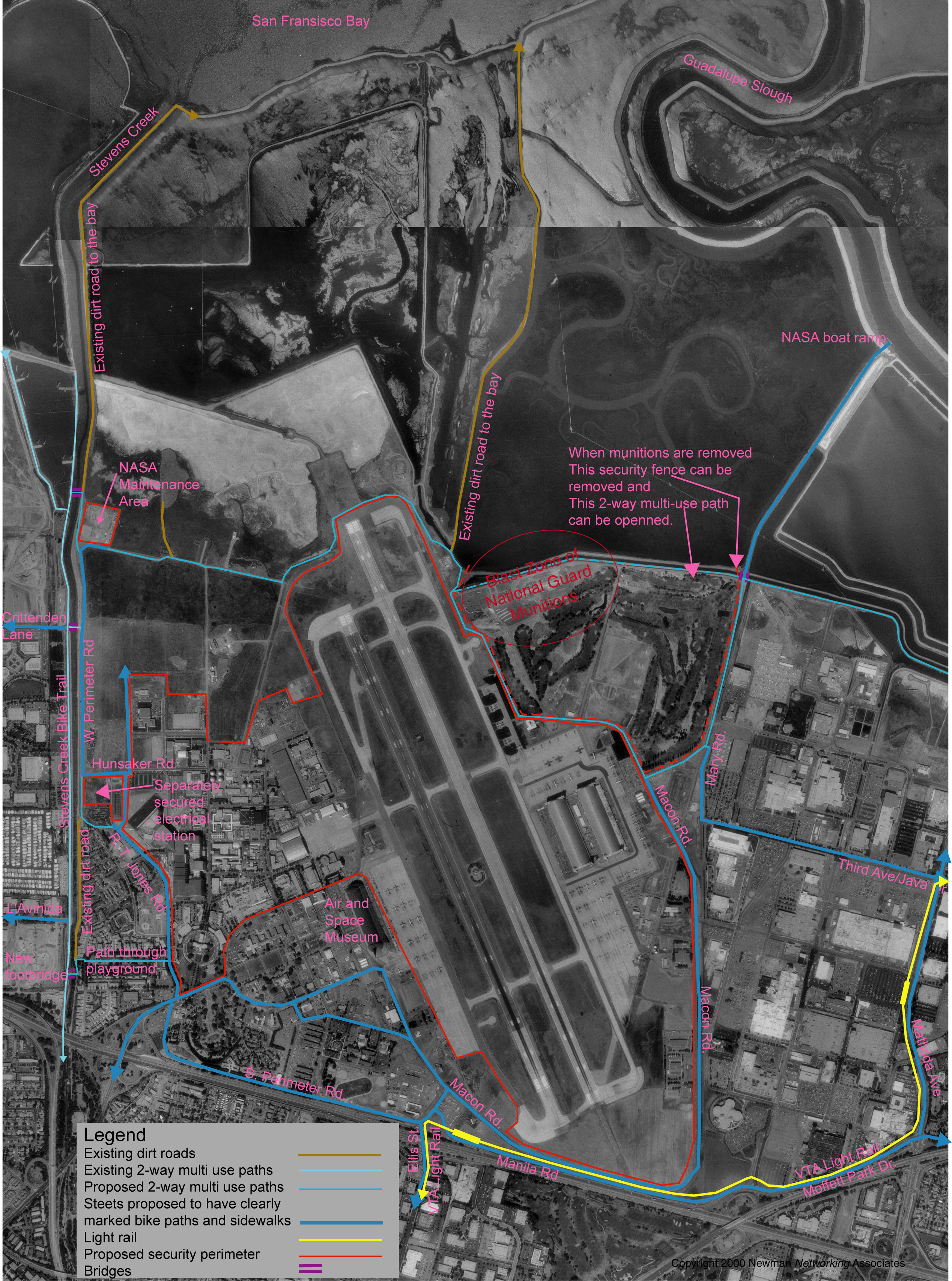
Map of proposed Bicycle and Pedestrian Routes
For full size map (2.3 MB) Click
Here.
For a pdf suitable for printing (2.5 MB) Click
Here
The proposals are represented on a map of the area.
This briefing and the map can be found on the web at http://www.newmannet.com/biketrails/moffett_plans.htm.
Features of the Plan:
- Completion of the Bay Trail is possible even without
moving the munitions stored in the golf course. The map shows the
approximate radius of the blast safety zone. While it blocks the
direct northern route (show as a dashed line) it allows a path south and
west of the bunker skirting the airfield. This will require a separate
security fence around the golf course (shown as a dashed line). If the
munitions are moved, the golf course security fence can be removed and the
northern route opened.
- Access from the west: The addition of a footbridge across Stevens Creek will
open access to the proposed Air and Space Museum from the west. We
propose locating this as shown where the existing concrete structures allow
a relatively short span. This will provide access from the Stevens Creek
Bike Path. The route into the facility that is shown assumes making a new
pedestrian gate in the fence between the old and the new residential
buildings. A 2-way multiuse path will continue from that gate across the
playground and connect with R.T. Jones Rd. This route will provide good
access both from the Stevens Creek Path and from the developed areas to the
west via L'Avenida and Crittenden
- Access from the south: The Moffett interchange will
provide bike and pedestrian access most directly to the museum area.
Ellis St. entrance and the light rail station provide access to Macon
St. Ellis interchange must be upgraded for bike and pedestrian access.
- Access from the east: On the east side, Third Ave. which is also Java Drive
becomes the main route through the unsecured part of the Lockheed area and
to the path around the area. The Lockheed light rail station connects via
Mathilda.
- Access from the north. The Bay Trail will have
access to the Bay View area. Continuing the R.T.Jones Rd. through a public corridor
approximately at Gate 17 will allow a connection between the
Research Park and the proposed Bay View area. The electrical station
would have a separate security perimeter.
- We assume that the security perimeter will encompass the areas that the research park
plan designates as either "ARC Facilities" or "East Side
Airfield". There is no reason for the research park, the proposed Bay
View development, the Wetlands, or any of the residential areas to be behind
security. Even if the Bay View option is not adopted, that area can be opened to the
public. In addition, we propose that the perimeter be inside Bascom Rd.
making that route available to the public. Given the height of the
light rail overhead wires, it is possible that moving the fence to the north
toward the landing strip will require only minor, or no, adjustment of
flight paths.